|
Getting your Trinity Audio player ready...
|
By Henry Owino
Turkana County, Kenya: As dawn breaks over Lake Turkana, the winds curl across the water, dragging waves toward the shrinking land. The emerald surface glitters with promise, yet beneath its quiet beauty lies turmoil. The world’s largest desert lake, once stable, isolated, and predictable, is rising fast, reshaping life for thousands along its shores.
When 54-year-old Naeku Ekal stands where her family home once stood, there is only water. It shimmers under the scorching Turkana sun, calm, deceptively beautiful, and deeply unsettling.
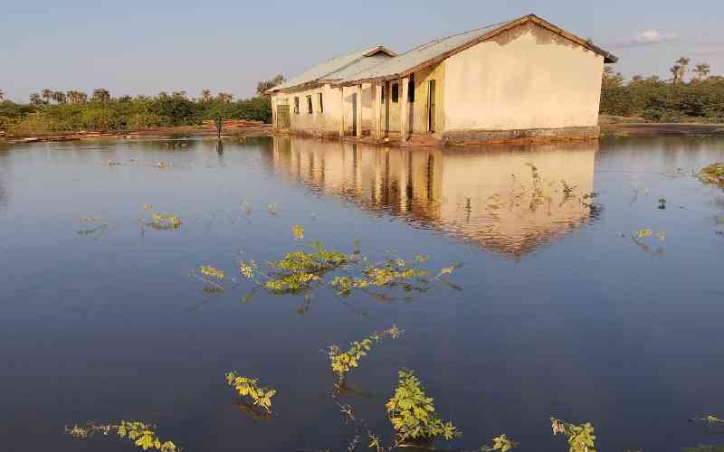
For generations, her community lived along these desert shores, fishing and herding goats. But today, the waters have swallowed everything: homesteads, schools, markets, shops, grazing land, farmland, burial grounds, public amenities, the list is long.
“We sleep afraid,” Naeku whispers, watching waves crash against an eroded shoreline. “Each night, the water moves closer.”
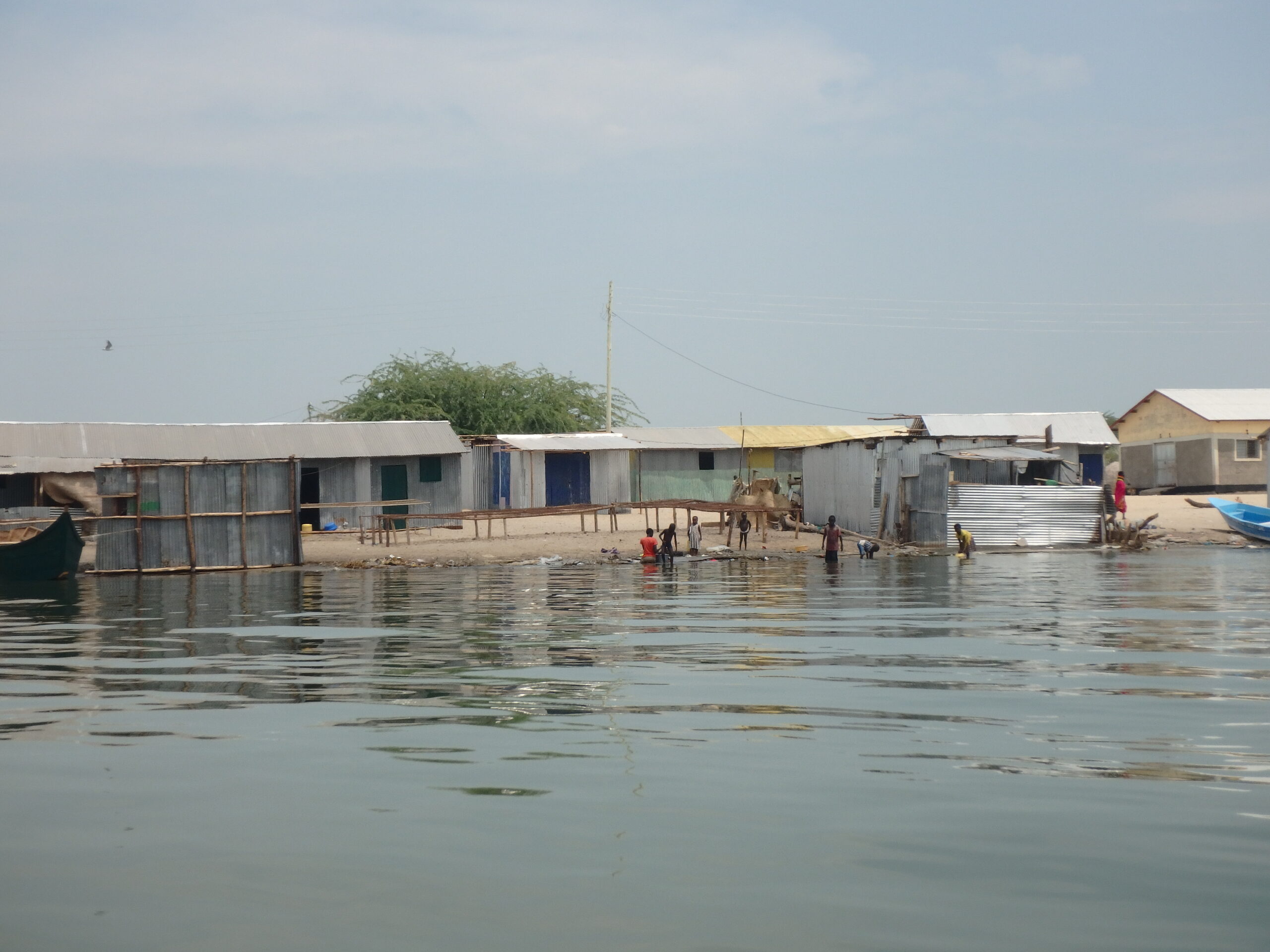
Long’ech: Residents in this area of Kang’atotha ward and along the lake shores have been affected by the rising waters.
In Kalokol village, Ekaale Ekal, a 63-year-old elder, stands barefoot where cattle grazed just a few years ago. Today, water laps at his ankles.
“That was our church,” he says, pointing to a distant ripple, where only the roof of a submerged structure peeks above the waterline. “We buried our elders on that side. Now the lake has taken everything, even our history.”
Ekaale has lived his entire life along Lake Turkana. His father fished in the same waters. His children were born here. But he fears his grandchildren may grow up as climate nomads, forever relocating ahead of the advancing shoreline.
Homes Turned into Water
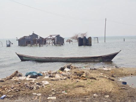
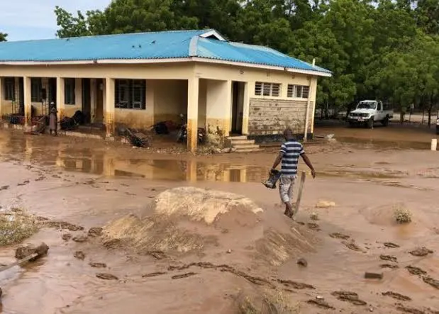
According to Kenya’s National Disaster Management Authority (NDMA), by mid-2024 over 400,000 people across Turkana County had been directly affected by the lake’s expansion. Entire villages shifted inland multiple times within four years, leaving behind skeletons of abandoned homes.
At Loruth village, rising water levels forced families to move, significantly reducing school attendance by nearly 40% by June 2024. The school where approximately 200 children once studied is now partially drowned, chairs and blackboards float inside classrooms during heavy winds.
Part of initial enrollment of 304 learners dropped due to parents relocating, highlighting urgent education needs in flood-prone areas. Currently, lessons are held under acacia trees until the trees fall to waves eating away their roots.
Community leader Achillae Lokol recalls when the shoreline was a kilometer away.
“The lake doesn’t move overnight,” he says. “It comes slowly, silently, like a thief. By the time you notice, it’s already inside your house.”
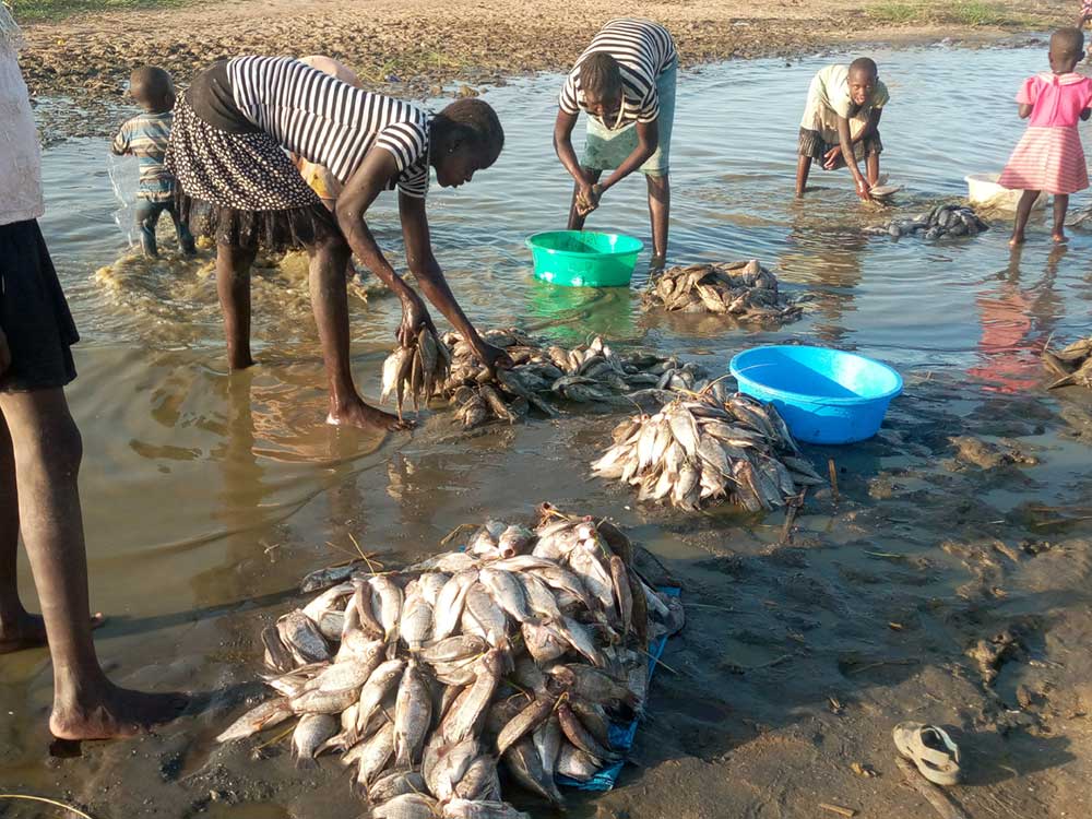
For mothers like Nasike Lomer, the losses go beyond infrastructure. Her small business drying and selling tilapia has collapsed.
“We used to spread the fish on the sand,” she explains. “Now we dry them on rooftops. Sometimes they blow away before they dry.”
Her husband has been traveling further into dangerous fishing zones, where stronger waves overturn wooden boats without warning. The community has lost at least 17 fishermen to storms this year alone, according to local beach management records.
Cultural Identity at Risk
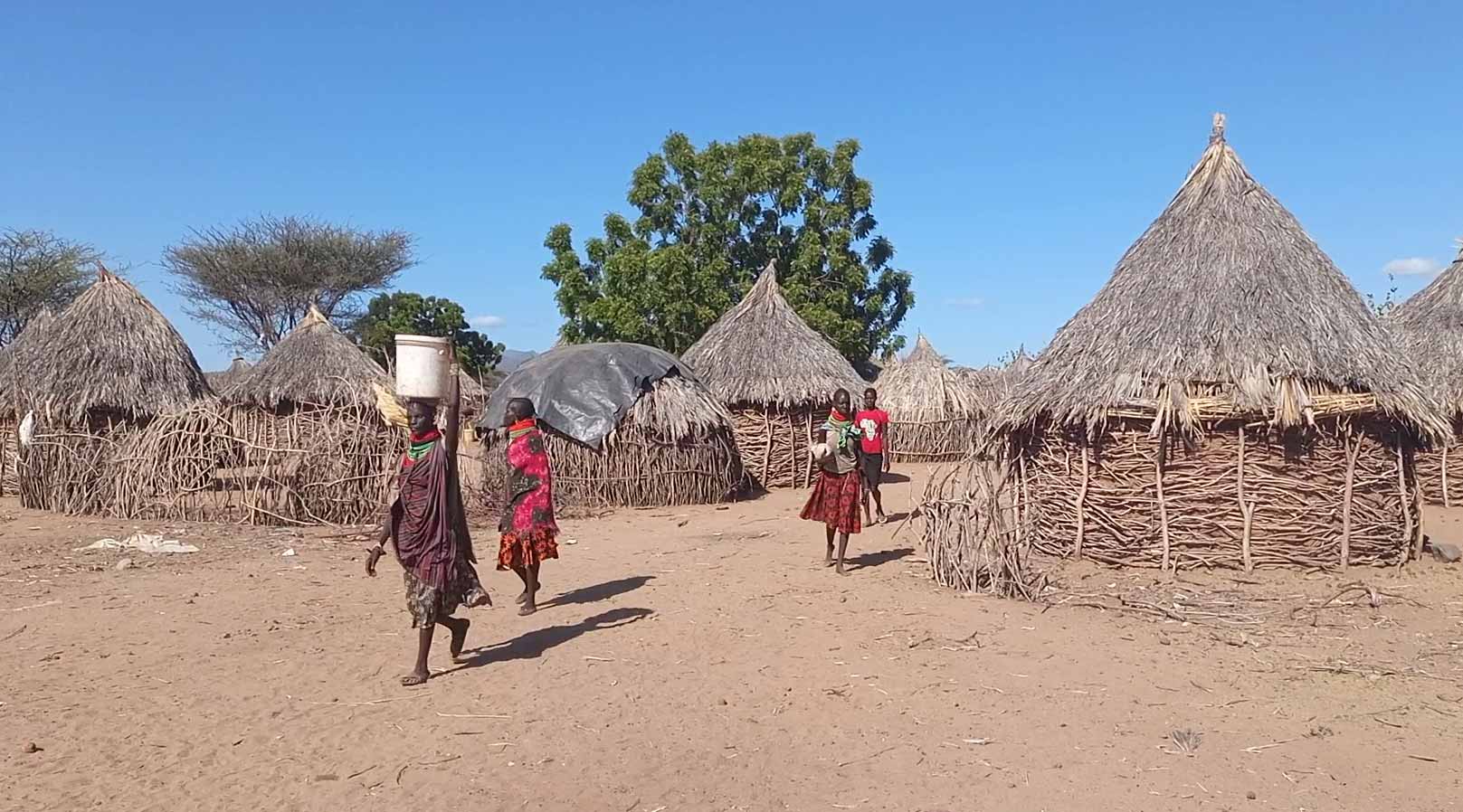
To the Turkana people, the shoreline is more than a boundary. It is a sacred geography tied to rituals, livestock traditions, and ancestral connections. But when graves disappear beneath water, families are forced to perform hurried spiritual rites, relocating stones and traditional markers to new ground often for the third or fourth time depending on flooding.
“When we bury our ancestors, we feel like we are losing our own souls,” Elder Ekaale discloses.
Ekaale recalls ceremonial grounds, once hubs of storytelling, conflict resolution, and marriage rites are now deep under water. Most elders are worried that cultural transmission could dissolve with the land.
According to the County Government of Turkana, the county is the second largest in Kenya covering 77,000 square kilometers thus 13% of the country’s total landmass. It is also the North-Western most northwestern county in Kenya known mostly for its scenic landscapes and rich culture.
Situated in Northern Kenya, Turkana County is well known for recurring droughts and strong winds. Lake Turkana is the region’s largest water resource, a shared resource between Kenya and Ethiopia with over 90 percent of the lake being in Kenya.
Lake Turkana, a semi-saline, closed-basin lake with no natural outlet, is primarily fed by three rivers: the Omo, Turkwel, and Kerio. The Omo River, originating in Ethiopia’s highlands, supplies over 90% of the lake’s water.
However, during the rainy season, seasonal rivers also contribute to the inflows. With no visible outflow, all water loss from the lake occurs through evaporation. The arid, desert-like climate of the region accelerates evaporation.
The lake is approximately 270 Km long, averages 30 Km wide, has a mean depth of 30 metres with a maximum depth of 120 metres making it the largest and deepest lake in Kenya, even larger than the Kenyan portion of Lake Victoria.
Lake Turkana, home to three national parks form a UNESCO World Heritage Site: Sibiloi, Central Island, and South Island that supports over 350 native and migratory bird species. It is vital for protecting endemic fish, birds, hippos, and Nile crocodiles, providing a unique habitat that supports their survival and biodiversity.
Additionally, the lake supports local livelihoods through fishing, transport and is a source of water for domestic use and watering of livestock.
Lake Turkana’s water levels have been rising in recent years, a rare and unexpected phenomenon for the surrounding communities. The rising water levels have submerged schools, offices, fish processing facilities, fish breeding grounds and whole villages, leading to loss of livelihoods, waterborne disease outbreaks, declining fish stocks and displacement of local population.
According to the Kenya Marine and Fisheries Research Institute (KMFRI), the lead government agency on fisheries and blue economy research in the country, Lake Turkana’s rising water levels may be caused by multiple factors.
Climate Change and Human Activities
James Last, a senior research scientist at the Kenya Marine and Fisheries Research Institute (KMFRI), says the primary driver of Lake Turkana’s rising water levels is heavy and prolonged rainfall in the catchment areas of its feeder rivers—particularly the Omo River, which supplies more than 90 percent of the lake’s inflow.
Human activities, he adds, have intensified the impacts of climate change, both deliberately and inadvertently.
“Long-term shifts in temperature and weather patterns, combined with human activities, are driving climate change here in Turkana,” Last explains. “Deforestation for charcoal and wood fuel, land clearing for farming, and construction have significantly worsened the situation.”
Last notes that land-use changes in the river basins have increased surface runoff into the lake. Clearing forests and expanding agriculture on steep slopes have reduced the land’s capacity to absorb rainwater, leading to soil erosion. As vegetation cover declines, runoff increases, carrying more sediment and water into rivers that feed Lake Turkana, accelerating siltation.
Strong, uninterrupted winds across the lake further compound the problem. Lake Turkana’s vast, open surface with few landmasses to break wind flow—allows winds to act on the water over long distances. Wind speeds frequently exceed 8–10 meters per second, generating large “wind waves” that push water far beyond the shoreline.
“The stronger the wind and the longer it blows, the larger the waves become,” Last says. “Wind strength and duration determine how far water floods inland.”
A United Nations Environment Programme (UNEP) study found that a strong negative Indian Ocean Dipole event between 2019 and 2020 triggered unusually heavy rainfall across eastern Africa, saturating the catchments that feed Rift Valley lakes, including Lake Turkana.
The study also showed that shifts in the balance between evaporation and precipitation, driven by increasing rainfall in the central equatorial Rift Valley, cooling toward the equator, and warming at the poles, are promoting lake expansion, particularly in closed (endorheic) basins like Lake Turkana.
According to UNEP, climate change over the next two decades is likely to bring heavier rainfall over Lake Turkana’s River inflows, raising water levels and increasing the risk of severe flooding. The report predicts a far wetter and potentially more dangerous future for the lake and nearly 15 million people living along its shores.
Last concludes that the recent and rapid rise in Lake Turkana’s water levels is the result of a combination of climate change, upstream land-use changes, extreme and erratic rainfall, and increased runoff from deforestation, forces that have caused the lake to expand dramatically in a relatively short time.
Socioeconomic Impacts
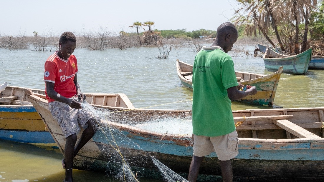
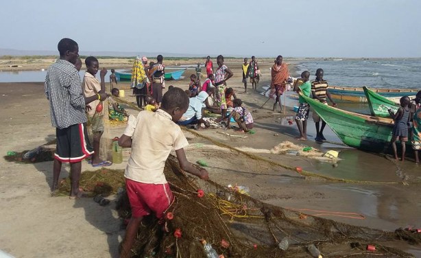
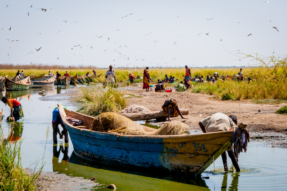
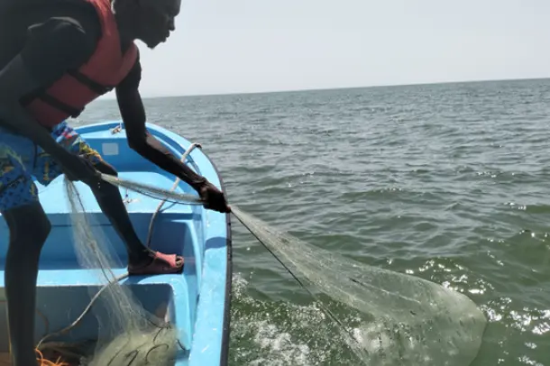
Fishermen at Long’ech peninsula, Kalokol town, and near Loiyangalani town are finding it rough in fish catch. While fishing is one of the economic mainstays of the community here, it is the continued rising water levels in Lake Turkana causing concern.
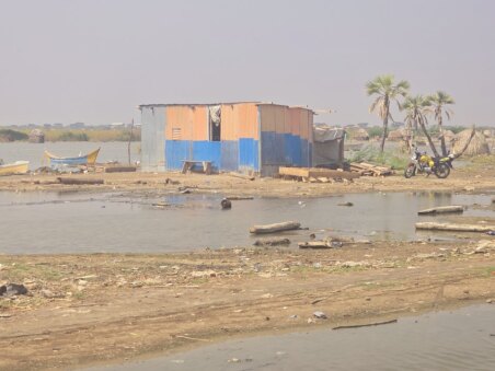
Residents outcry houses and business premises in the low-lying areas are adversely affected, infrastructure is submerged and other structures are inaccessible. The rising waters are worrying residents and scientists.
“The rising water levels has not only continued to displace thousands of local residents, but it has also disconnected roads, submerged schools, churches, hotels, hospitals, latrines, graves and disrupted normal fishing activities,” John Ekenon, motorbike rider explains.
Ekenon says people living along the lake have been witnessing a steady increase in water since 2016 with rapid swelling from 2020.
David Ekuom, fisherman at Kalokol town on the western shores says fisherfolks are adversely affected by lake level rise which destroyed their homes, landing beaches and offices for Beach Management Units (BMUs). Most residents’ livelihoods in town are dependent on fish either directly or indirectly in terms of income or sources of food.
“Residents lost lives, properties, businesses, source of income and were cut off from the rest of the community in terms of roads inaccessibility. Downed power lines by water increase left the place without electricity, and therefore affecting businesses and increasing insecurity in the town,” Ekuom laments.
Kalokol town is about 3 km from the Lake Turkana shoreline, but it remains at risk as lake water continues to increase. Many villages, including Nakiria, are already surrounded by lake water, and Kalokol itself could soon be submerged.
Alternative Jobs
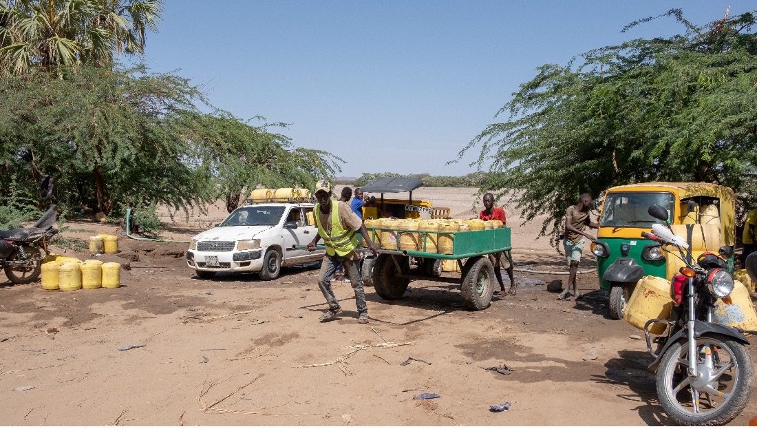
Ekuom fishing experience says the lake water level rose and moved inland from its original levels. As a result, it created new shorelines covering parts of Kalokol town. Young men have turned to alternative jobs after losing their primary sources of income due to declining fish stocks.
They now operate motorbikes, offer boat rides, water vending and work as tour guides to sustain their livelihoods.
He admits Long’ech Peninsula may be inundated as lake water levels continue to rise. Though residents have been cautioned to move out to safer higher grounds, a few people are still hesitant to relocate.
“Personally, as a fisherman, I lived in Longe’ch.” Apart from fishing, I operated a retail shop but I had to shut it down and move to Kalokol since the water kept rising then. Basically, unless the government forcefully moves people, life continues despite foreseeable risks,” Ekuom regrets.
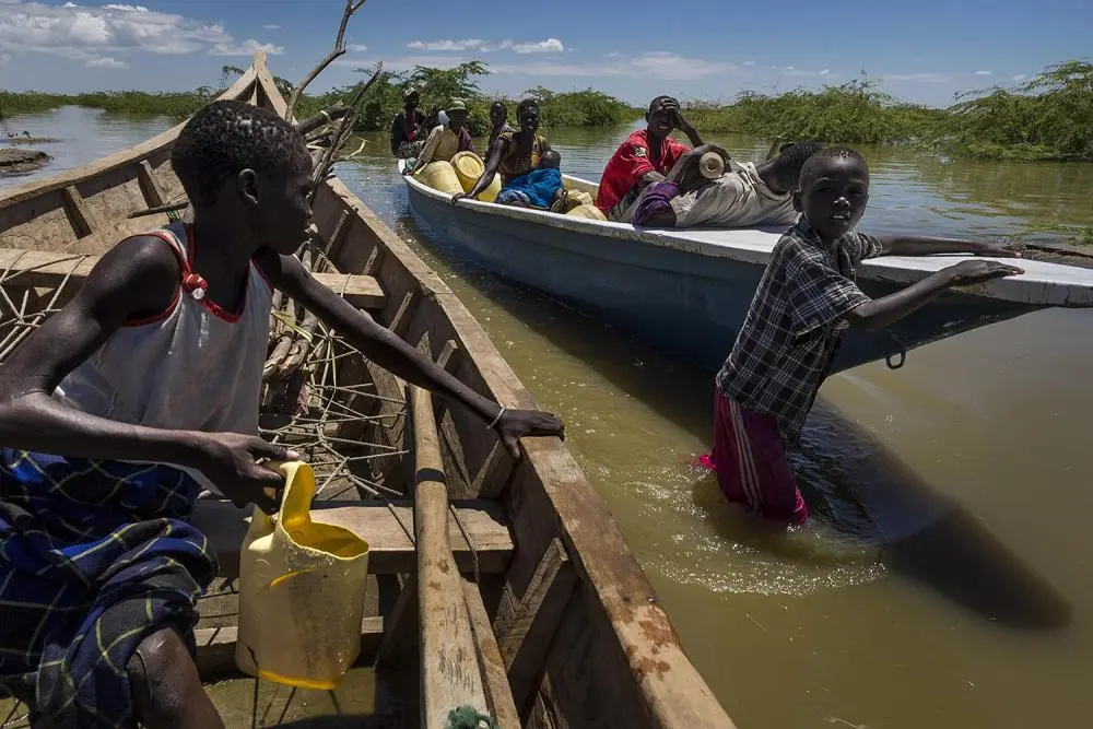
In Long’ech, the reality is that many residents found themselves trapped, homeless, frustrated and constantly on the move. It takes about 30 minutes to cross by motorboat from Kalokol to Longe’ch costing Ksh 200 ($1.54) one way. Commercial boats take about half an hour or more to get passengers to fill the boat.
Long’ech, residents are similarly not sure of the real cause of the lake swelling. Here, everybody has their own version, others blaming Ethiopians for releasing excessive waters from the dams in Omo River while others point a finger to River Turkwel.
Josephat Namuya, fisherman at Long’ech says, the waters are spilling to villages at an alarming rate. It is like the lake is claiming back its position taken away many years ago. He notes that life is tough on Longe’ch, where fishing is the main socio-economic activity yet their stocks are dwindling.
According to Moses Njeru, The Turkana County Fisheries Officer says many families living next to the lake are adversely affected and displaced.
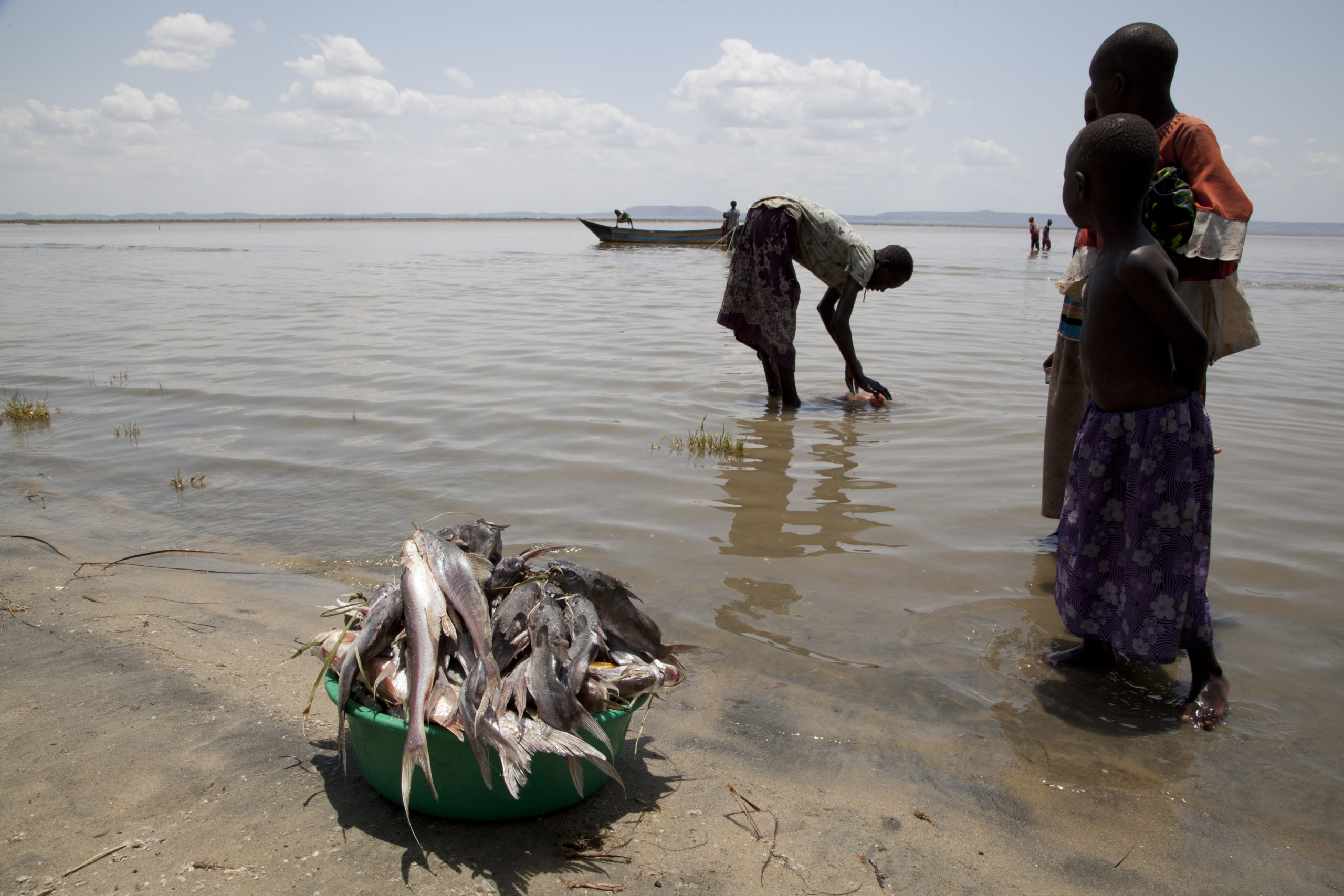
According to official figures from the Turkana County Government, 15,000 tonnes of fish are landed from the lake each year valued at about US $4.1 million.
“Over two thousand households, who primarily rely on fishing for their livelihoods, are staring at starvation due to the devastating effects of the swelling lake and flooding,” Njeru reveals.
Normal life altered, schools closed, surges of water borne diseases such as cholera, typhoid, dysentery cases. The outbreak of the diseases was contained by early detection, diagnosis and treatment. Public health workers and local Non-Governmental Organizations (NGOs) workers were vigilant to ensure that fish traders’ corridors did not become epidemic highways.
“We have been warned by environmental experts and scientists from KMFRI that the lake may continue to swell and they have advised that we should have contingency measures for the affected fishing villages and infrastructure. People are really worried and stressed, yet the rains are not falling, so they blame River Omo in Ethiopia for all disasters,” Njeru noted.
Peter Eregae, a fish trader in Kalokol who takes fish from the lake to other towns like Kisumu, Kitale, Busia and even Kampala in Uganda had to stop the trade. He has worked in this business for nearly 20 years, but since 2023, running the business has become too costly.
The decrease in fish availability has forced Eregae to halt his transportation business. Furthermore, many fishermen have been displaced from their residences and operational shorelines. Filling a refrigerated truck now requires significantly more time: it takes 7-9 days to amass only 1 or 2 tonnes of fish, a sharp decline from previous years when it took just 3-4 days to fill 4 or 5 tonnes for transport.
“Though the road linking Kalokol and Kitale is now tarmacked, fish stocks in Lake Turkana have greatly reduced making business worthless,” Eregae laments.
Tectonic Shifts — the Natural Movement of Earth’s Crust
John Malala, a principal research Scientist at Kenya Marine and Fisheries Research Institute (KMFRI) in Turkana County, says slow tectonic movements beneath Lake Turkana may be reshaping the lake basin, similar to changes seen in Rift Valley lakes such as Nakuru, Baringo, Naivasha, and Bogoria, which have expanded despite no major increase in rainfall.
Geological shifts are a significant factor, according to Malala, who explains they can disrupt underground drainage, block natural exits, and activate underwater springs. This activity traps surplus water and intensifies flooding. Malala largely discounts rainfall as the main cause, citing that high rates of evaporation and percolation would restrict its influence.
Furthermore, he points out that siltation from rivers, particularly the Omo, which is aggravated by erosion and changes in land use in both Kenya and Ethiopia, has diminished the lake’s storage volume. This reduction in capacity is a further element contributing to the escalating water levels.
Ethiopia’s Dam Construction
The rising water levels in Lake Turkana have been partly attributed to spillage from the Turkwel Dam in Kenya’s West Pokot County, though this is not the primary cause of the floods.
The construction of the Gibe III Dam on Ethiopia’s Omo River has been a major concern for environmentalists and civil society groups in Turkana County.
They argue that the dam has negatively affected the Omo River’s flow into Lake Turkana, leading to interference with fish breeding zones and a subsequent drop in fish stocks. Environmental activists, particularly those under the Friends of Lake Turkana (FoLT) umbrella, have been vocal in opposing such large-scale dams due to these negative impacts.
“Our engagement with local communities is to raise awareness about the threats to Lake Turkana and its ecosystem through empowering them to participate in environmental protection efforts and advocating for their rights,” Ikal Angelei clarifies.
“We also advocate through lobbying on decision-makers like elders, chiefs, and opinion leaders to take action to protect the environment and ensure sustainable development. So, taking legal actions to protect the rights of communities and the environment is our concern,” Angelei says.
Emmanuel Ekalale, fisherman complains that water levels in the lake have risen endangering hundreds of residents along the shores amid fears that nearby Kalokol town may soon be submerged. He confirms there is depletion of fish stocks resulting in a decrease in food supply from the lake, economic loss, hardship to fishers and disruption of traditional ways of life.
“Ironically, Lake Turkana was previously at risk of drying up due to the construction of the Gibe III hydroelectric power dam in Ethiopia. Again, we are told by environmental experts that severe flooding is due to unanticipated swelling of Lake Turkana caused by overflow from River Omo, main supplier which originates in the Ethiopian Highlands,” Ekalale complained.
The continuous rise in water levels is a major concern for local residents, the County Government, and scientists. Fishermen, in particular, are incurring losses amounting to millions of shillings due to the ongoing swelling of the lake.
Lake Salinity Levels
Principal Research Scientist John Malala says Lake Turkana typically floods during the July–October rainy season, but the current rise is unprecedented and ongoing, causing widespread displacement and destruction.
“This is not normal flooding,” Malala notes, adding that KMFRI scientists were surprised by the sustained increase. Communities in Kalokol, Long’ech, and Namukuse are among the worst affected, with schools, health facilities, graves, and public infrastructure submerged.
Despite the increase in water, the lake’s salinity, according to Malala, has not changed. Nevertheless, the sharp drop in fish catches has forced many fishers to find other ways to earn a living. Malala also notes that water levels in Ferguson’s Gulf, which is a vital fish breeding area, have risen from approximately 3.5 metres to 5 metres.
Volcanic Activity — Fire Beneath the Lake
The swelling of Lake Turkana, though beginning gradually in 2016, dramatically accelerated by mid-2020, according to Maurice Obiero, a senior research scientist and KMFRI station coordinator in Turkana County.
Obiero reports that the rapid rise in water levels has alarmed residents. Consequently, he has issued multiple advisories urging people to relocate to higher ground, as Long’ech village faces imminent complete submersion and parts of Kalokol town are also under threat.
Obiero notes that rising water levels are affecting lakes across the Rift Valley, driven in part by volcanic and tectonic activity beneath the basin. “Unusual lake level changes have been occurring since 2010,” he says.
Rising water levels in Lake Turkana are profoundly impacting the region, particularly Turkana Central, where at least 2,000 families have been displaced and significant property loss is reported.
Driven by climate change, geological shifts, and upstream pressures, scientists warn the lake is expected to continue swelling. For residents along the shore, the threat is immediate and tangible, measured by how close the water creeps to their homes. Elders recount losing ancestral graves and ceremonial grounds to the advancing water.
As the wind picks up and waves advance each evening, families rush to haul their nets and belongings higher, uncertain if their efforts will be enough by morning.
Life persists despite the lake’s harsh and beautiful unpredictability. The water is quietly, yet relentlessly, reshaping lives at the desert’s edge. Fishermen continue their dawn routines, mothers strive to rebuild businesses on the diminishing land, and children find new spaces for joy, wading through lagoons that have overtaken their former homes.
Government and Stakeholders Crisis Response
In response to the worsening floods, the Turkana County Government has formed a multi-sectoral task force to coordinate emergency response and long-term mitigation.
James Wangiros, the County Executive Committee Member (CECM) for Public Service, Administration, and Disaster Management, says the team is focusing on inter-agency coordination, community engagement, and building resilience against future floods.
Key measures include clearing blocked drainage, repairing culverts, promoting sustainable land use such as reforestation and soil conservation, and distributing relief food and non-food items to displaced families.
Local authorities are urging residents in flood-prone areas to relocate to higher ground. The county is distributing essential supplies, including tents and mosquito nets, to support the affected population.
Efforts are underway to restore water services, with Water Services CECM Patrick Losike overseeing the repair of damaged boreholes and the implementation of contingency plans to maintain supply in Lodwar.
Furthermore, Lands CECM Peter Akono has stressed the necessity of allocating new land for displaced families and developing long-term climate adaptation strategies, such as shoreline protection.
Humanitarian aid is also being provided. The Salvation Army is offering emergency relief and psychosocial support, delivering vital items like clean water, food, hygiene kits, blankets, tents, clothing, and footwear to households impacted by the floods.
This story has been produced in partnership with InfoNile and with funding from JRS Biodiversity Foundation and IHE Delft’s Water and Development Partnership Programme. It’s a collaborative effort between Henry Owino, journalist based in Nairobi and James Last, a Senior Research Scientist with KMFRI based in Kisumu.


